
The Australian National Directory of Important Migratory Shorebird Habitat:
SUPPORTING AUSTRALIA'S MIGRATORY BIRDS IN THE AREAS MOST CRITICAL FOR THEIR SURVIVAL
For over 60 years, volunteers have tirelessly given their time to count migratory shorebirds on Australia’s coasts and important inland ecosystems. These high quality, repeated surveys have enabled identification of important migratory shorebird habitat across Australia.
Birdata is thrilled to introduce The Australian National Directory of Important Migratory Shorebird Habitat, hereby referred to as “the Directory”. This is BirdLife Australia’s newest and most comprehensive assessment of critical migratory shorebird areas within Australia. Designed as a tool to support habitat protection and land management for conservation organisations, government, and land managers, the Directory includes 15 years of data from dedicated volunteers.

ABOUT THE DIRECTORY
Establishing a directory of important shorebird habitat is not a new concept, with the 2025 Directory the fourth of its kind since the early 1990s. The Directory includes a 350-page detailed report, however it is Birdata’s interactive spatial data tool that is most innovative in this new update which enables users to visually explore, filter, and download relevant data instantaneously. Data which has been collected over 15 years (between 2009-2024) from BirdLife Australia’s Australian Shorebird Monitoring Program (ASMP) as well as 10 years of data from the Latham’s Snipe Project, a closely affiliated project focussed on monitoring Latham’s Snipe in southeastern Australia.
Being funded by the Australian Government’s Renewables Environmental Research Initiative (RERI), the Directory contributes to the Government’s commitment to transitioning to renewables and a net zero target whilst protecting Australia’s biodiversity, including threatened bird species. The Directory identifies 332 important non-breeding sites that support at least one of Australia’s 37 regularly occurring migratory shorebirds based on either international or national quantitative criteria.
MIGRATORY SHOREBIRDS OF THE EAST ASIAN-AUSTRALASIAN FLYWAY
Migratory shorebirds are wading birds that regularly migrate across international boundaries throughout their life cycle. Under the national Environment Protection and Biodiversity Conservation Act 1999 (EPBC Act), there are currently 37 migratory shorebird species listed, each considered a Matter of National Environmental Significance (MNES). The East Asian-Australasian Flyway (EAAF) is a threatened migratory shorebird route passing through 22 countries from far east Russia and Alaska, through East and South-east Asia, and down to Australia and New Zealand. Australia provides important non-breeding habitat for northern hemisphere migratory breeding species in this flyway. Important migratory sites need to remain healthy and productive to ensure migratory birds obtain sufficient food and rest required for their return north for breeding. Juveniles and immature birds typically stay within Australia for two years before making their journey north. It is these non-resident EAAF species that are the focus of the Directory.
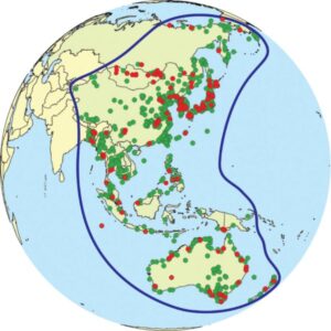
Image: The blue line indicates the extent of the East Asian-Australasian Flyway (EAAF). Green points indicate important sites for migratory waterbirds. Red points show specific sites in the Flyway Site Network through the East Asian-Australasian Flyway Partnership (EAAFP), which Australia is a partner of.
DATA ANALYSIS
Data Collection
Most of the data collected for the Directory came from coordinated counts at established Shorebird Areas (SBAs), administered by BirdLife Australia in the ASMP. The ASMP was formerly known as Shorebirds 2020, and prior to that, the Australasian Wader Studies Group (AWSG)’s Population Monitoring Program. The AWSG continue to support and inform the ASMP. Most of the raw data is housed in Birdata.
Site Selection
To be selected as an important shorebird habitat, sites needed to adhere to the criteria of regularly supporting species with:
INTERNATIONAL
- An abundance of at least 1% of a Flyway species’ population using the site (using the global standard under the Ramsar Convention on Wetlands); or
- An aggregation of at least 20,000 waterbirds in total.
NATIONAL
- An abundance of at least 0.1% of a Flyway species’ population using the site; or
- An abundance of at least 0.1% of the Flyway population of a single migratory shorebird species (or 18 birds for Latham’s Snipe); or
- An aggregation of at least 2,000 migratory shorebirds; or
- Species diversity of at least 15 migratory shorebird species.

* Whilst only existing SBAs that used the same standardised protocols were analysed, the Directory acknowledges there are other sites that can support significant numbers of shorebirds that are not currently surveyed, and therefore the Directory cannot be considered exhaustive. Audits of other data sources and extensions of monitoring could broaden the SBA monitoring network in the future.
Seasonal Selection
The Directory used two seasons for count data: austral summer (September-April) when migratory birds arrive in Australia and numbers typically peak, and winter (May–August). These are based on ecologically relevant ‘shorebird’ seasons rather than calendar seasons.
Methodology
To ensure the selection of sites were scientifically robust, only the best available and most comprehensive data was used to estimate species abundance, diversity, and aggregation. Vetting was also undertaken and any duplicates removed.
Abundance: Population estimates for migratory shorebirds were produced by van Swinderen et al. (2025) based on ASMP data from 2012 to 2022. If there were a range of population estimates, the middle value was selected to provide a conservative estimate and to account for uncertainty.
Species diversity: Species diversity was defined seasonally as “the maximum number of different species a given shorebird area supported in a single season.”
Shorebird aggregation: Shorebird aggregates were defined by “the maximum total number of migratory shorebirds of any species in a given shorebird area supported during a single survey event in a season.”
Any site that met or exceeded an importance threshold at least once in either species abundance, diversity, or aggregation was included in the Directory.
Results
After robust analyses, 332 sites across all states and territories were identified including:
- 104 internationally significant sites
- 187 nationally significant sites
- 41 significant sites for Latham’s Snipe
Many of these were existing national and/or international sites of significance through other mechanisms including Ramsar, the Australian Government’s Directory of Important Wetlands of Australia, and the Flyway Site Network. In the spatial tool, Ramsar sites have also been overlayed so users can see where important SBAs and Ramsar sites intersect.

INTERACTIVE ONLINE SPATIAL DATA TOOL
The online interactive spatial and data tool created and hosted by Birdata, enables users to explore the Directory data using filters including species, state, shorebird areas (SBAs), seasons, and species importance (national and/or international). Through the SBAs page, users can look at all, or a specific SBA and see in what season and year it reached either an international or national threshold through its peak count. GPS coordinates of the SBA are also provided with a link directly to the map where the SBA boundaries are shown along with a pop up of the species found at that SBA and their associated peak counts.
The online platform is updatable, and csv files can be directly downloaded to support users. To make the online tool accessible and quick to load, simple SBA layers have been used for efficiency, however, high resolution versions are available through the BirdLife Australia public library.
A CASE STUDY: FAR EASTERN CURLEW
The Far Eastern Curlew is critically endangered with population declines of 80% since the 1990s. Far Eastern Curlews face many threats across their range including disturbance in Australian roosting and feeding sites, as well as loss of intertidal habitat in important stopover sites in the Yellow Sea. Spending 60% of their cycle in Australia per year (more than any other country) it is important that nonbreeding sites are protected and human disturbances limited to ensure Far Eastern Curlews have the energy to travel 20,000 kms annually.
Human recreational use including off-leash dogs, walking and fishing can impose energetic costs to birds which can have detrimental impacts on their survival. In southeast Australian non-breeding areas, Far Eastern Curlews have had steep declines which are thought to be attributed to increased human pressures such as growing population numbers and coastal development. Moreton Bay in southeast Queensland is an existing Ramsar site with complex intertidal flats that has been identified as an important shorebird area in the Directory. The Directory has identified this area as important to Far Eastern Curlews with international thresholds of abundance being surpassed for all years of the 15-year study.
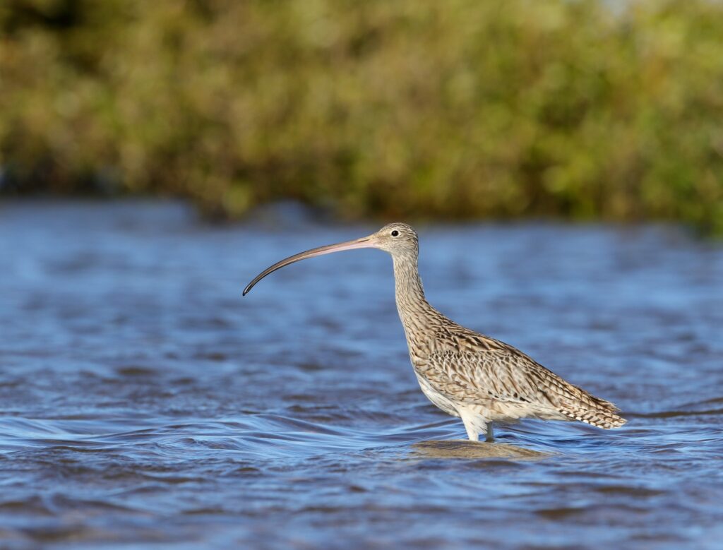
Image: Far Eastern Curlew – Les George, 2020.
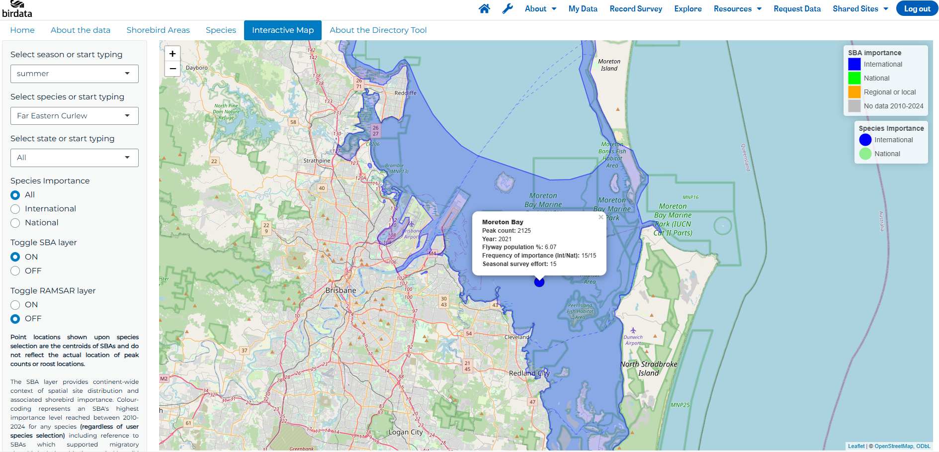
Image: Example of the online interactive Directory tool for Far Eastern Curlews in the shorebird area (SBA) of Moreton Bay. Note the point is a centroid point of the SBA and does not indicate the actual location of peak counts or roost locations. The pop-up text box for the species provides a quick overview of the species’ peak count and year it occurred, the estimated percentage of the Flyway population using the SBA, the number of years the species hit an important national or international threshold, and the number of years (over the 15 year study) surveys were conducted.

Image: Port Phillip volunteers – Ryan Kilgower
THE DIRECTORY: A TESTAMENT TO VOLUNTEER POWER
The Directory, informed by volunteers and researchers, provides a strategic framework to prioritise areas for protection, guide conservation management, and support environmental assessments. It is vital that Australia supports threatened migratory shorebirds in their non-breeding areas to contribute to the overall health of populations across the international Flyway. Whilst the Directory is extensive and backed by long-term data, there are still significant gaps of survey effort across the continent particularly in remote inland areas and difficult to access areas in northern Australia. With a vast 35,800 km of mainland coastline and 23,800 kms of island coastlines, the ASMP needs more resourcing and volunteers to support migratory shorebird monitoring.
The Directory is a testament to the power of volunteers and citizen science in monitoring and protecting the shorebirds we love.
Thanks to all the volunteers that made the Directory possible
Standardised population monitoring of shorebirds has occurred since the 1980’s, supported by special-interest groups such as the Australasian Wader Studies Group and Queensland Wader Study Group. The Australian Shorebird Monitoring Program run by Birdlife Australia now houses decades of continent-wide shorebird count data.
We are grateful to all volunteers and collaborators who made this project possible including: Latham’s Snipe Project; Australasian Wader Studies Group; Queensland Wader Study Group, Western Australian Wader Study Group; Victorian Wader Study Group; New South Wales Wader Study Group; Friends of Shorebirds South East; the Crocodile Islands Rangers; BirdLife Australia’s regional branches and observatories; Broome Bird Observatory; Eyre Bird Observatory; Birdlife Australia’s Birdata team and the Beach-nesting Birds Team. This project highlights how standardised, long term data collection can guide conservation decision making for our migratory shorebirds.
Want to learn more?
To join a dedicated migratory shorebird count or to contribute to general standardised bird surveys within Birdata, please visit https://birdlife.org.au/volunteer-opportunities/national-shorebird-monitoring/ or https://birdata.birdlife.org.au/. To access the Migratory Shorebird Directory online spatial data tool and full report, visit https://www.dcceew.gov.au/environment/epbc/publications/national-directory-important-migratory-shorebird-habitat or https://birdata.birdlife.org.au/migratory-shorebird-directory-2025.